We left SE Michigan in the first part of November 2014. Unless otherwise stated each map represents a one day drive. Sometimes we string together 3 or 4 days in a row of hard driving, usually not. Sometimes we spend a day, sometimes a month in one spot. A few maps represent a day trip, where we do not drag Tana along, I try to remember to tell you which day trips do NOT include Tana.
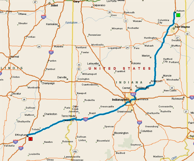
Map 1. Starts about 100 miles from home, we drove about 388 miles this day. It was a LONG day. Even tho the map starts at Auburn Indiana, our first stop was at Effingham Illinois.
Map 1. Starts about 100 miles from home, we drove about 388 miles this day. It was a LONG day. Even tho the map starts at Auburn Indiana, our first stop was at Effingham Illinois.
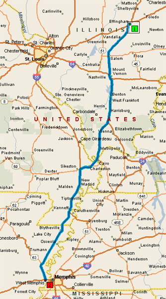
Map 2. Effingham Illinois to West Memphis area, about 300 miles.
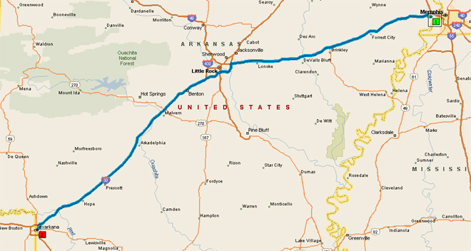
Map 3, West Memphis to Texarkana Arkansas, about 270 miles.
Map 4, Texarkana Arkansas to near Weathersford Texas, about 240 miles.

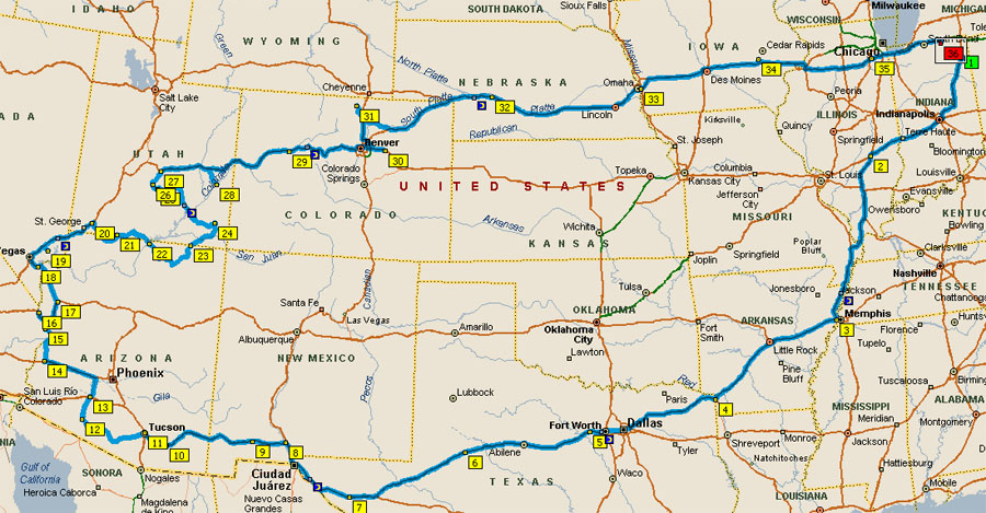
Map 5, Weatherford Texas to Big Spring Texas, about 230 miles.

Map 6, Big Spring to Van Horn Texas, about 225 miles.

Map 7, Van Horn Texas to Las Cruces New Mexico, about 165 miles.

Map 8, Las Cruces to Deming New Mexico, about 60 miles.

Map 9, Deming New Mexico to Benson Arizona, about 170 miles.

Map 10, Benson to Tucson Arizona, about 50 miles.

Map 11, Tucson to Ajo Arizona, about 135 miles.

Map 12, Ajo Arizona to Brenda Arizona, about 165 miles.

Map 13, Brenda Arizona to BLM land north of Quartzsite Arizona, about 25 miles, give or take.

Map 14, BLM land, Quartzsite to Lake Havasu Arizona, about 70 miles

Map 15, Lake Havasu Arizona to Needles California, about 50 miles.

Map 16, Needles back to Lake Havasu (yes, we did, we went back for the fireworks shows), about 50 miles, same as Map 15, in reverse
Map 17, Lake Havasu back to Needles, about 50 miles, same as Map 15.
Map 18, Needles California to Kingman Arizona, about 62 miles.

Map 19, Kingman Arizona to Lake Mead Nevada/Boulder City Nevada, about 80 miles.

Map 20, Lake Mead Nevada to Valley of Fire, Nevada about 66 miles.

Map 21, Valley of Fire Nevada to Leeds Utah, about 115 miles.

Map 22, This was a DAY trip. Tana did NOT accompany us. We drove Jolly. 252 miles. Left Leeds, north to Cedar City, east past Cedar Breaks National Park area, to 89. North through Hatch to Bryce Canyon. Reverse direction, down 89 to 9 to go through Zion and back to Leeds.

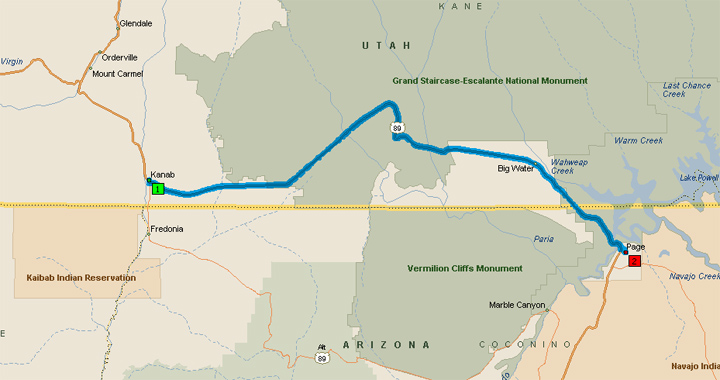
Map 23, Leeds Utah to Kanab Utah, about 80 miles.

Map 24, Kanab Utah to Page Arizona, about 75 miles
Map 25, Page Arizona to Monument Valley Utah, about 125 miles.

Map 26, Monument Valley Utah to Torrey Utah, about 240 miles. This was my personal favorite drive of the winter.

Map 27, Torrey Utah to Moab, about 175 miles

Map 28, Moab Utah to Glenwood Springs Colorado, about 200 miles.

Map 29, Glenwood Springs to Byers Colorado, about 200 miles, and 11,100 feet at the Johnson/Eisenhauer Tunnels.

Map 30, Byers to Livermore Colorado, about 120 miles, plus a few more to get us up the mountain to where friends Ron and Terrie A live.

Map 31, Livermore Colorado to North Platte Nebraska, about 266 miles.

Map 32, North Platte Nebraska to Council Bluffs, Iowa, about 285 miles.

Map 33, Council Bluffs to Amana Iowa, about 230 miles.

Map 34, Amana Iowa to Joilet Illinois, about 220 miles.

Map 35, the final run, Joilet to home. Map stops at Middlebury, Indiana. We are about 120 miles give or take from there. So, last run was about 250 or so.

The entire trip, the map as shown is about 5200 miles. Trip was more miles. Total not available, just yet.
Map 5, Weatherford Texas to Big Spring Texas, about 230 miles.
Map 6, Big Spring to Van Horn Texas, about 225 miles.
Map 7, Van Horn Texas to Las Cruces New Mexico, about 165 miles.
Map 8, Las Cruces to Deming New Mexico, about 60 miles.
Map 9, Deming New Mexico to Benson Arizona, about 170 miles.
Map 10, Benson to Tucson Arizona, about 50 miles.
Map 11, Tucson to Ajo Arizona, about 135 miles.
Map 12, Ajo Arizona to Brenda Arizona, about 165 miles.
Map 13, Brenda Arizona to BLM land north of Quartzsite Arizona, about 25 miles, give or take.
Map 14, BLM land, Quartzsite to Lake Havasu Arizona, about 70 miles
Map 15, Lake Havasu Arizona to Needles California, about 50 miles.
Map 16, Needles back to Lake Havasu (yes, we did, we went back for the fireworks shows), about 50 miles, same as Map 15, in reverse
Map 17, Lake Havasu back to Needles, about 50 miles, same as Map 15.
Map 18, Needles California to Kingman Arizona, about 62 miles.
Map 19, Kingman Arizona to Lake Mead Nevada/Boulder City Nevada, about 80 miles.
Map 20, Lake Mead Nevada to Valley of Fire, Nevada about 66 miles.
Map 21, Valley of Fire Nevada to Leeds Utah, about 115 miles.
Map 22, This was a DAY trip. Tana did NOT accompany us. We drove Jolly. 252 miles. Left Leeds, north to Cedar City, east past Cedar Breaks National Park area, to 89. North through Hatch to Bryce Canyon. Reverse direction, down 89 to 9 to go through Zion and back to Leeds.
Map 23, Leeds Utah to Kanab Utah, about 80 miles.
Map 24, Kanab Utah to Page Arizona, about 75 miles
Map 25, Page Arizona to Monument Valley Utah, about 125 miles.
Map 26, Monument Valley Utah to Torrey Utah, about 240 miles. This was my personal favorite drive of the winter.
Map 27, Torrey Utah to Moab, about 175 miles
Map 28, Moab Utah to Glenwood Springs Colorado, about 200 miles.
Map 29, Glenwood Springs to Byers Colorado, about 200 miles, and 11,100 feet at the Johnson/Eisenhauer Tunnels.
Map 30, Byers to Livermore Colorado, about 120 miles, plus a few more to get us up the mountain to where friends Ron and Terrie A live.
Map 31, Livermore Colorado to North Platte Nebraska, about 266 miles.
Map 32, North Platte Nebraska to Council Bluffs, Iowa, about 285 miles.
Map 33, Council Bluffs to Amana Iowa, about 230 miles.
Map 34, Amana Iowa to Joilet Illinois, about 220 miles.
Map 35, the final run, Joilet to home. Map stops at Middlebury, Indiana. We are about 120 miles give or take from there. So, last run was about 250 or so.
The entire trip, the map as shown is about 5200 miles. Trip was more miles. Total not available, just yet.
No comments:
Post a Comment